


- Katie James
- Post Doctoral Fellow
- SPrEaD: Spreading the Geospatial Semester into New Territory
- Northwestern University
- Robert Kolvoord
- https://www.jmu.edu/isat/people/faculty/kolvoord-bob.shtml
- Dean
- SPrEaD: Spreading the Geospatial Semester into New Territory
- James Madison University
- Steven McGee
- https://thelearningpartnership.academia.edu/StevenMcGee
- President
- SPrEaD: Spreading the Geospatial Semester into New Territory
- The Learning Partnership
- Jose Sotello
- Graduate Researcher
- SPrEaD: Spreading the Geospatial Semester into New Territory
- Northwestern University
- David Uttal
- http://groups.psych.northwestern.edu/uttal/
- Professor
- SPrEaD: Spreading the Geospatial Semester into New Territory
- Northwestern University
Public Discussion
Continue the discussion of this presentation on the Multiplex. Go to Multiplex
Katie James
Post Doctoral Fellow
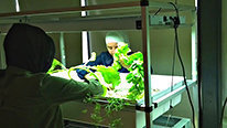
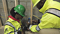
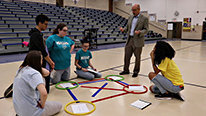
Welcome to the Chicago Geospatial Semester Project video! The goal of this project is to explore how to infuse GIS, a state-of-the-art geospatial visualization tool, into Career and Technical Education (CTE) in the Chicago Public Schools (CPS) and, secondarily, in other CPS content areas.
During our first year of implementation, we have been working to customize project supports around the specifics of each content area and the unique needs of CPS CTE students. What have you found to be the best ways to support teachers in using GIS in their classrooms? We look forward to your insights and guidance on this issue and any other questions or feedback you have about the project.
Meriem Sadoun
David Campbell
Program Officer (retired)
Very cool project! The Geotech Center might have some resources that you might be able to use (or vice versa): http://www.geotechcenter.org/ Have you looked at many environmental justice issues, like food deserts, etc.?
David Uttal
Professor
Our work is student driven, so we go with what they want to work on. But yes, some social justice issues do come up. One is access to health care. I believe that one of our collaborators, Rich Schultz, works with GeotechCenter.org. Thanks for your interest. DHU
Katie James
Post Doctoral Fellow
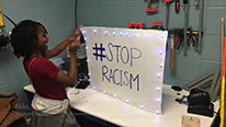
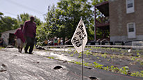
Thanks so much for that great recommendation! A few other cool projects related to environmental justice have come up in our classrooms this year. One group examined differences in average weekly food costs for families around the world and how that relates to proximity to different types of agriculture (e.g. factory farms, local farms). Another group explored food desserts in Chicago and throughout Illinois and considered the impact of wealth and transportation on food access.
Robert Kolvoord
Dean
The Geospatial Semester in Virginia (https://www.isat.jmu.edu/geospatialsemester/), an inspiration for this project, has seen many environmental justice issue projects over the years as student interest has definitely trended in this direction. We're long-time acquaintances of the GeoTech Center and appreciate their efforts.
Molly Phillips
This is really amazing program! I had no idea that geospatial skills are being taught in high school at such a level. The project I work for is helping to mobilize geospatial biodiversity data from natural history collections. We are also building lesson plans and modules to teach both geospatial and data literacy using biodiversity data. One example is we have students map suitable habitat and then projected human population growth and have them propose prospective reserve sites for endangered species. We would love to collaborate with existing programs like SPrEaD. Is there interest in using biodiversity data in your curricula?
Steven McGee
President
Hi Molly,
We are very interested in making new datasets available to the teachers. Our initial partnership with the Chicago Public Schools (CPS) has been within the Career and Technical Education program. We are also exploring how to incorporate GIS into the sciences in CPS. Your project seems like a great resource.
Molly Phillips
Let me know if you would like to talk more after this program. My email is mphillips@flmnh.ufl.edu
David Uttal
Professor
Yes, the most important factor in making GIS accessible to high school students has been teacher involvement and professional development. Robert Kolvoord (see his response above) has been active for about 15 years in developing these programs, and in recruiting and developing teachers.
Mary Murphy
Instructor
Awesome work! Loved the brief descriptions of the kinds of questions kids were exploring. I have had lots of PD around GIS but have always been limited in implementing because of limited access to technology to run. We are an iPad high school with limited access to laptops. Can you explain what technology a school would need to implement? How were teachers trained to be able to support students in developing their own questions that they also could answer with the data.
Robert Kolvoord
Dean
Mary - Thanks for the comments. We're using the ArcGIS Online package. It runs fine on iPads, through a browser. ESRI makes the accounts available for free (check out https://www.esri.com/en-us/industries/education/licensing). ArcGIS Online is a real game changer in terms of access (no installation, no software licenses) and ease of use. There are lots of introductory lessons available at https://learn.arcgis.com/en/
Steve shared some of our PD. We're happy to answer other questions as you have them.
Steven McGee
President
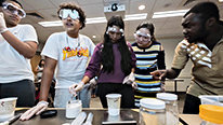
We are fortunate that the teachers have access to technology through the CTE program. We are using ArcGIS online as that supports the minimum level of technology that the schools have. All K12 schools can get free access to ArcGIS online through ESRI. As indicated above by Bob Koolvord, this project is modeled after the Geospatial Semester program in VA. The team from VA has come out to Chicago to engage teachers in 2 days of workshops on GIS early in the summer. The teachers spend time doing tutorials and planning lessons (with stipends). Later in the summer, the VA team came back to Chicago for additional 2 days of GIS professional development and feedback on the lessons. Part of our research question is around building capacity locally sustain the program. The program is being initially embedded in courses that are already project-based, so we are capitalizing on the strengths of the teachers in guiding student projects. Our research is documenting these strategies so that we can better distill these strategies and share them with future teachers.
Alec Bodzin
Fantastic project!
What challenges are you facing with your implementation?
David Uttal
Professor
Hello Alec Bodzin. I'll let Katie James respond to this, as she is writing a paper on the challenges and successes surrounding implementation.
Katie James
Post Doctoral Fellow
We've learned so much from our teachers who have been doing the work of aligning GIS to their content area and the needs of their students this year! We're beginning to understand some of the challenges and successes involved in introducing GIS in the classroom. One challenge has been around the best ways to introduce and build capacity with the GIS technology. We've found that starting simple and gradually building complexity with technical skills has been key. We're generating a recommended progression for introducing GIS that builds on what we've learned from our observations this year. Another challenge has been the need for both in the moment and ongoing technical support. We're developing support structures, including GIS mentors and lesson resources, to help support teachers as these roadblocks come up.
Jacob Grohs
Assistant Professor
Thanks for sharing! I love the idea of students pursuing the projects they are interested in and identifying, collecting, and/or exploring data of interest to them. It seems this sort of pedagogical approach may also require some training for some teachers totally separate from the GIS technical skills. How comfortable have all teachers been in using this sort of approach? What are some things that seem to work best in scaffolding towards this aim?
Jonathan Lewis
Nice video and very encouraging work. Thanks! The social justice and environmental justice empowerment dimensions are rich. We certainly need more problem solvers getting into STEM fields with a sense of urgency and recognizing that there is gainful employment in addressing many local challenges, from drinking water to urban soil chemistry, from watershed health to coastal subsidence. Great work!
Katie James
Post Doctoral Fellow
Thanks for your question, Jacob! There are some teachers for whom this approach has been a more natural fit with their practice. We've encouraged the teachers to make it their own and have seen a variety of successful approaches emerge. Based on our observations, we are developing a set of key instructional/design principles, such as using culturally responsive pedagogy and student-driven inquiry as well as creating a collaborative community of learners. We've created opportunities to share this developing set of principles, along with examples of these practices in the classroom, with the teachers. We've also incorporated debriefing meetings during which teachers share their reflections on the lessons they have designed and implemented.
We would love to hear about what other folks have done to support this type of instructional approach!
Mary Murphy
Instructor
Any chance you will be offering PD for other regions?
Steven McGee
President
As a SPREAD project, we are working to understand what key ingredients need to be in place for this program to sustain in Chicago. We hope that what we learn will be of benefit to districts in other regions. In a few years, towards the latter part of our project, we would be in a better position to talk with other district about conducting professional development.
Catherine Haden
Great project! To what extent do the students' reflections suggest that they are able to transfer what they are learning to other contexts and problem solving situations?
Steven McGee
President
Great question, Catherine. I will let David and Bob share what they are learning from the VA implementation of Geospatial Semester. In Chicago, we are in the process developing the assessments for the GIS-infused CTE courses. We will first be examining near transfer to see if students can apply GIS spatial reasoning to CTE career cluster areas other than their own career cluster area.
Robert Kolvoord
Dean
Catherine- Thanks for the comment. David Uttal, Adam Green (Georgetown) and I have been collaborating on a project with students in the Virginia version of the Geospatial Semester. One of the things we've measured is students' STEM problem solving skills and comparing them between students in the GIS class and a comparison group. We see the GIS students develop stronger STEM problem-solving skills (such as identifying evidence and arguing from the evidence). David can share more of the details, but we're encouraged. We also see the GIS students apply more spatial strategies. even in situations where they wouldn't be expected or required, such as some kinds of analogical reasoning. As our work in Chicago continues, hopefully we'll be able to explore some of these same questions.
Further posting is closed as the showcase has ended.